Bren Ananta location overview - Kaggalipura on NH-209
Bren Ananta is located at Kaggalipura on the NH-209 (Kanakapura Road) frontage in south Bengaluru. The plot is one of the last large undeveloped parcels on this stretch of the corridor, sitting between the urbanised Talaghattapura–Konanakunte belt to the north and the semi-rural reach toward Kanakapura town to the south.
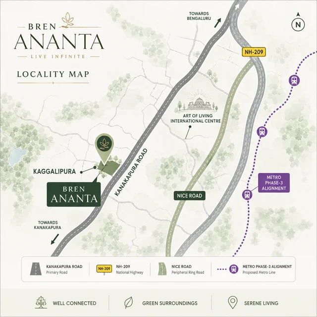
Connectivity from Bren Ananta
| Route | From the project |
|---|---|
| NH-209 (Kanakapura Road) | Direct frontage |
| NH-209 Bypass (proposed) | Eastern boundary, 0 m |
| NICE Road – Kanakapura Road interchange | ~12 km north |
| Outer Ring Road (Silk Board / Bannerghatta) | ~14 km north-east |
| Electronic City (Phase 1) | ~22 km via NICE |
| Whitefield ITPL | ~38 km via NICE + ORR |
| Silk Institute Metro (Green Line) | 6.3 km |
| Thalgattapura Metro | ~7 km |
| Konanakunte Cross Metro | ~10 km |
| Kempegowda International Airport | ~60 km via NICE + Bellary Road |
Nearby landmarks within 10 km of Bren Ananta
| Landmark | Distance |
|---|---|
| Art of Living International Centre | 1.3 km |
| Kaggalipura Lake | 2.6 km |
| Thottikallu Falls | 5.5 km |
| Yashasvi International School | 6.1 km |
| Silk Institute Metro | 6.3 km |
| The Home School | 6.5 km |
| Shankar Super Specialty Hospital | 7.8 km |
| DMart | 8 km |
| Turahalli Forest | 8.3 km |
| Cloudnine Hospital | 9 km |
| Falcon City Mall | 10.2 km |
Kanakapura Road micro-market - the corridor in context
Kanakapura Road, designated as National Highway 209, is the southern axis of Bengaluru that runs from Bommanahalli on the inner ring to Kanakapura town, Malavalli, and onward toward Mysuru via the alternative south-western route. Within the Bengaluru metropolitan boundary, the corridor cleanly splits into three economic zones: the dense urbanised stretch from Jayanagar 9th Block through Banashankari and JP Nagar, the consolidated mid-suburban belt from Konanakunte through Doddakallasandra and Vajarahalli, and the still-expanding southern reach from Talaghattapura through Kaggalipura toward Harohalli. Bren Ananta sits in that third belt - close enough to reach the consolidated suburb in 15 to 20 minutes off-peak, far enough to escape the high-density block typologies that dominate it.
The corridor's strategic value comes from three converging public-infrastructure programmes. First, the NHAI six-laning of NH-209 from NICE Road junction to Kaggalipura, with median improvements and grade-separated junctions at Vajarahalli and Talaghattapura, has materially improved drive times into the inner city. Second, the BMRCL Green Line metro extension from its current terminus at Silk Institute toward Hejjala and Anjanapura adds a credible mass-transit option once commissioned. Third, the proposed NH-209 Bypass alignment, which abuts the Bren Ananta site on the eastern boundary, gives long-distance traffic a parallel route - once operational, it reduces commercial truck and outstation bus pressure on the existing alignment, which is precisely the road that runs past the project entrance.
Demand-side, the corridor's primary buyer base draws from south-Bengaluru employment nodes - Electronic City and the Konappana Agrahara IT cluster, the JP Nagar–Bannerghatta back-office belt, the Mysore Road manufacturing arc, and the growing biotech and medical-devices cluster around Bommanahalli. A secondary catchment comes from the Art of Living International Centre, which generates year-round residential and pilgrimage footfall and supports a service economy of cafes, organic stores, and yoga-and-wellness studios within a 3 km radius of the project.
Drive-time map from Bren Ananta - workday commute reality
For any Bengaluru buyer, the relevant question is not the static kilometre count but the actual peak-hour drive time. We have triangulated drive-time estimates across off-peak (after 10:30 AM), morning peak (8:00–9:30 AM inbound), and evening peak (6:00–8:00 PM outbound) windows using common-route data observed across the corridor.
| Destination | Off-peak | Morning peak | Evening peak |
|---|---|---|---|
| JP Nagar 9th Phase | 22 min | 32 min | 40 min |
| Banashankari 6th Stage bus stand | 28 min | 40 min | 48 min |
| Electronic City Phase 1 (via NICE) | 40 min | 55 min | 1 hr 10 min |
| Bannerghatta Road IIM | 45 min | 1 hr | 1 hr 15 min |
| Silk Board junction | 50 min | 1 hr 10 min | 1 hr 25 min |
| Whitefield ITPL (via NICE + ORR) | 1 hr 10 min | 1 hr 40 min | 2 hr |
| Manyata Tech Park (via NICE) | 1 hr 5 min | 1 hr 30 min | 1 hr 45 min |
| Kempegowda International Airport | 1 hr 15 min | 1 hr 30 min | 1 hr 30 min |
The honest read: Bren Ananta works comfortably for buyers whose daily anchor is in south or south-east Bengaluru. For Whitefield or Manyata commuters, the drive math is the binding constraint - buyers should road-test the commute themselves on a typical weekday morning before committing, rather than relying on Google's optimistic projections.
Schools, hospitals, and daily-life infrastructure within 10 km
The Kaggalipura belt has matured from a thin services base in 2015 to a credible daily-life ecosystem in 2026, driven by the cumulative residential additions along the corridor. Education options now span CBSE, ICSE, IB, and Cambridge curricula within a 10 km arc:
- Schools (CBSE): Yashasvi International School (6.1 km), The Home School (6.5 km), Delhi Public School South (8 km), Suchitra Academy (9 km)
- Schools (ICSE / IB): Greenwood High International (10 km via NICE), Inventure Academy (12 km), Sri Kumaran Public School (10 km)
- Pre-schools and Montessori: Tree House, Founding Years, Little Mozart, EuroKids - all within 4 km of the project entrance
- Hospitals (multi-specialty): Shankar Super Specialty (7.8 km), Cloudnine (9 km), Apollo Spectra (10 km), Fortis Bannerghatta (14 km), Sakra World (18 km via NICE)
- Daily groceries and retail: DMart (8 km), Reliance Smart (5 km), MK Retail (6 km), Vasudev Adigas, Polar Bear, A2B outlets along the corridor
- Malls and large-format retail: Falcon City Mall (10.2 km), Gopalan Innovation Mall (12 km), Mantri Square Bashyam Circle (15 km), Forum South Bangalore (14 km)
- Banking, ATMs, and last-mile services: SBI, HDFC, ICICI, Axis branches within 4 km; multiple petrol pumps (IOC, BPCL, HP) on the NH-209 stretch between Talaghattapura and Kaggalipura
The closest large hospital with a full critical-care, cath-lab, and trauma capability is Shankar Super Specialty at 7.8 km - a 12-minute off-peak drive. For tertiary procedures, Fortis Bannerghatta and Apollo Bannerghatta sit within a 25-minute window using NICE Road.
Metro, bypass, and corridor capital projects on the horizon
Three infrastructure programmes will reshape the Kanakapura Road corridor between 2026 and 2030, and each one influences the holding-period value of Bren Ananta in a distinct way.
Namma Metro Green Line - Reach 4B extension: The currently operational Green Line terminates at Silk Institute, 6.3 km north of the project. The Phase 3 extension has been notified by BMRCL, with detailed project reports advanced for the Anjanapura–Hejjala–Bidadi alignment. Once commissioned, the closest planned station to Bren Ananta would be in the Hejjala vicinity, placing the project within a 3–4 km drive of an operational metro station. The timeline remains contingent on land acquisition and central funding approvals, so prudent buyers should not price this in as a near-term certainty.
NH-209 Bypass: The NHAI-notified bypass alignment runs along the eastern boundary of the Bren Ananta plot and is designed to absorb long-distance commercial traffic that currently uses the existing NH-209 alignment through Kaggalipura village. When commissioned, the existing road past the project entrance becomes the local-traffic carriageway, with materially improved noise, dust, and accident-risk metrics. Construction sequencing has begun on the Bengaluru–Mysuru access-controlled corridor segments, and the Kanakapura-direction bypass is in the active project pipeline.
NICE Peripheral Ring Road integration: NICE Road's Kanakapura Road junction is approximately 12 km north of the project. NICE provides a controlled-access route to Electronic City (south-east), Tumkur Road (north-west), and the airport-bound Bellary Road via the Bangalore–Mysore expressway interchange. The state-government-sanctioned Peripheral Ring Road, when complete, will add a second outer orbital, further improving long-distance accessibility for residents.
Neighbourhood texture - the daily-life feel of Kaggalipura
Numbers and distances tell only half the story; the more important question for a long-horizon homeowner is what the neighbourhood actually feels like on an ordinary Tuesday. Kaggalipura today reads as a transitional belt - close enough to the urbanised suburb of Talaghattapura to share its retail and services base, far enough to retain a recognisable village rhythm with the Saturday weekly market, the temple festival cycle, and the surviving agricultural plots on the eastern flank toward the proposed bypass alignment. For buyers coming from the dense inner south of Bengaluru - Banashankari, JP Nagar, Jayanagar - the contrast is immediate: less horn-pressure on the road, longer sky-lines through the canopy, and a much shorter cognitive distance between the apartment door and an open landscape.
The Art of Living International Centre 1.3 km away anchors a year-round footfall of residential students, teacher-training cohorts, international visitors, and weekend wellness seekers. The visible knock-on effect on the immediate retail strip is a denser-than-expected concentration of organic produce stores, vegetarian cafes, yoga-and-wellness studios, and ayurvedic clinics within a 3 km radius. The flip side is a manageable weekend traffic spike on the NH-209 stretch immediately past the Centre - Sunday mornings in particular see a 20–30% lift in inbound traffic that buyers should factor into weekend errand planning.
The Kaggalipura Lake at 2.6 km is a regulated water body under the BBMP lake-rejuvenation programme, with a perimeter walking path, restored bunds, and active migratory-bird seasons in the November–February window. The lake's catchment and the adjacent Turahalli minor forest contribute meaningfully to the corridor's micro-climate - average summer afternoon temperatures here run 1.5–2 degrees cooler than the inner-suburb readings, an empirical pattern that residents of the corridor cite consistently and that urban-heat-island studies have documented across multiple monsoon cycles.
Bren Ananta location FAQ
Where exactly is Bren Ananta located?
Bren Ananta is located off NH-209 (Kanakapura Road) at Kaggalipura, Bengaluru South 560082. The site sits inside the Kaggalipura pocket near the Bannerghatta-Kanakapura overlap, with direct Kanakapura Road frontage and a short approach via the village service road.
How far is Silk Institute Metro from Bren Ananta?
Silk Institute Metro Station, the current southern terminus of Namma Metro's Green Line, is approximately 6.3 km from the Bren Ananta site - a 12 to 18 minute drive depending on traffic. The metro extension toward Anjanapura is in operational planning.
What schools are near Bren Ananta?
Delhi Public School South, NPS Banashankari, Valley School and Sri Kumaran Children's Home are all within a 15 to 25 minute drive via Kanakapura Road and the JP Nagar feeder roads. Sishu Griha (the Bren-affiliated K-12 school) is approximately 14 km in JP Nagar.
What hospitals are near Bren Ananta?
Apollo Cradle, Fortis Bannerghatta, and Sagar Hospitals on Kanakapura Road are within a 20 to 30 minute drive. For day-to-day primary care, Greenpark Clinic and several local diagnostic centres operate within a five-kilometre radius of Kaggalipura.
How long is the airport drive from Bren Ananta?
Kempegowda International Airport is approximately 48 km via NICE Road and the elevated airport expressway - a 60 to 90 minute drive depending on time of day. The NICE Road on-ramp at Bommasandra and Krishna Bhairaveshwara junctions are the standard exit points.
Talk to the Bren Ananta sales team
Request the current cost sheet, floor-plan PDF, and a site-visit slot at Kaggalipura, Kanakapura Road.
Contact us